
SPOKANE, Wash. — Looking ahead to the upcoming winter season, La Niña conditions are likely to develop for the second straight year.
Forecasts from the Climate Prediction Center give about a 70-80% chance for weak La Niña conditions to occur from about October 2021 to January 2022.
La Niña and El Niño is a an observation of ocean temperature anomalies near the equator in the Pacific Ocean that can have a direct impact on weather patterns globally. The influence on the weather pattern is strongest over North America during the winter months.
La Niña is when those ocean waters are colder than normal. The temperature departure can range from 0.5° to 2° Celsius colder than normal. The greater the difference, the stronger the La Nina is and more likely it is to influence weather patterns. This winter is expected to be a "weak" La Nina, with temperature departures only expected after 0.6° to 0.7° Celsius cooler than normal.
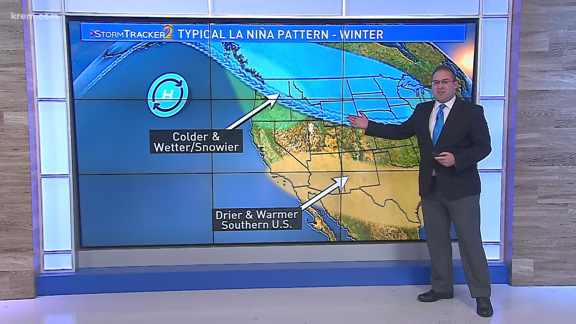
Think of La Niña's influence on weather patterns as a domino effect. Cooler ocean waters mean that winds over the Pacific are stronger than normal with means rainfall decreases over the northern-tropical Pacific Ocean and so on. The strength and placement of the jet streams, columns of fast-moving air that circle both the northern and southern hemispheres, is a noticeable effect of La Niña.

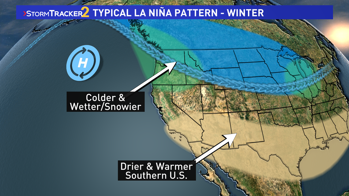
The polar jet stream tends to ridge over a semi-permanent High Pressure over the North Pacific and dips towards the Pacific Northwest. This tends to result in weather systems that push cold and moist airmass into our region. So colder and wetter winter is favored, and for Spokane that can lead to more snow than normal.
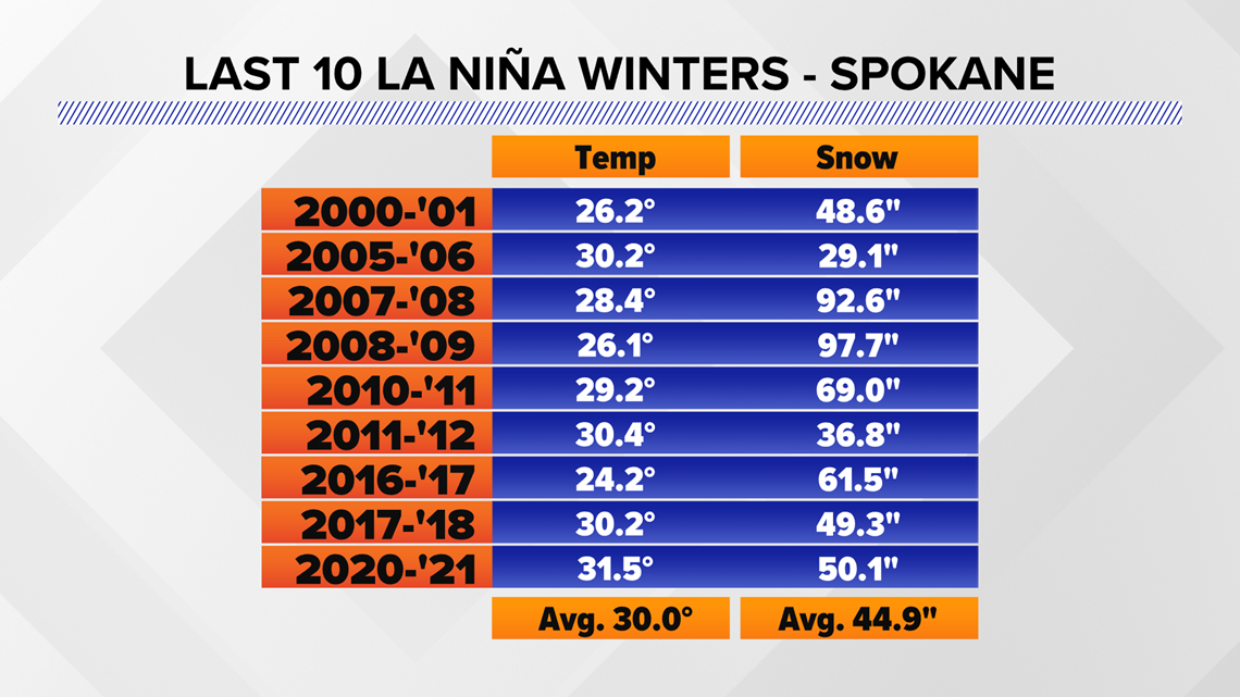
The record setting winters of 2007-08 and 2008-09, where more than 90 inches of snow fell, were both La Niña winters.
But this isn't a guarantee that all winters are colder and snowier than average in Spokane or the area. In fact, the winter of 2020-21 ended up being slightly warmer than normal by 1.5°F. That in turn took what could've been a very snowy January into a very rainy January. Thus, the season didn't get as much snow as originally forecasted, but at 50.1 inches of snow was still slightly snowier than the normal season for Spokane.

But just because Spokane's La Niña forecast wasn't perfectly on par with the textbooks, it doesn't mean the rest of the country's was off. Western Washington got more rain and snow compared to average, with Snoqualmie reporting their highest snow depth in 10 years. The southwestern U.S. always was much drier than average, which is very common during La Niña for that part of the county.
While it's not a perfect correlation, about six or seven out of every 10 La Nina winters do end up colder than snowier than average in Spokane. That means it's more appropriate to say that La Niña favors those conditions, rather than guaranteeing them.
NOAA's Climate Prediction Center will release their 2021-22 Winter weather outlook in October while KREM2 Chief Meteorologist Tom Sherry will have the Inland Northwest's long-range winter forecast in November 2021.