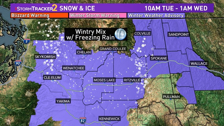
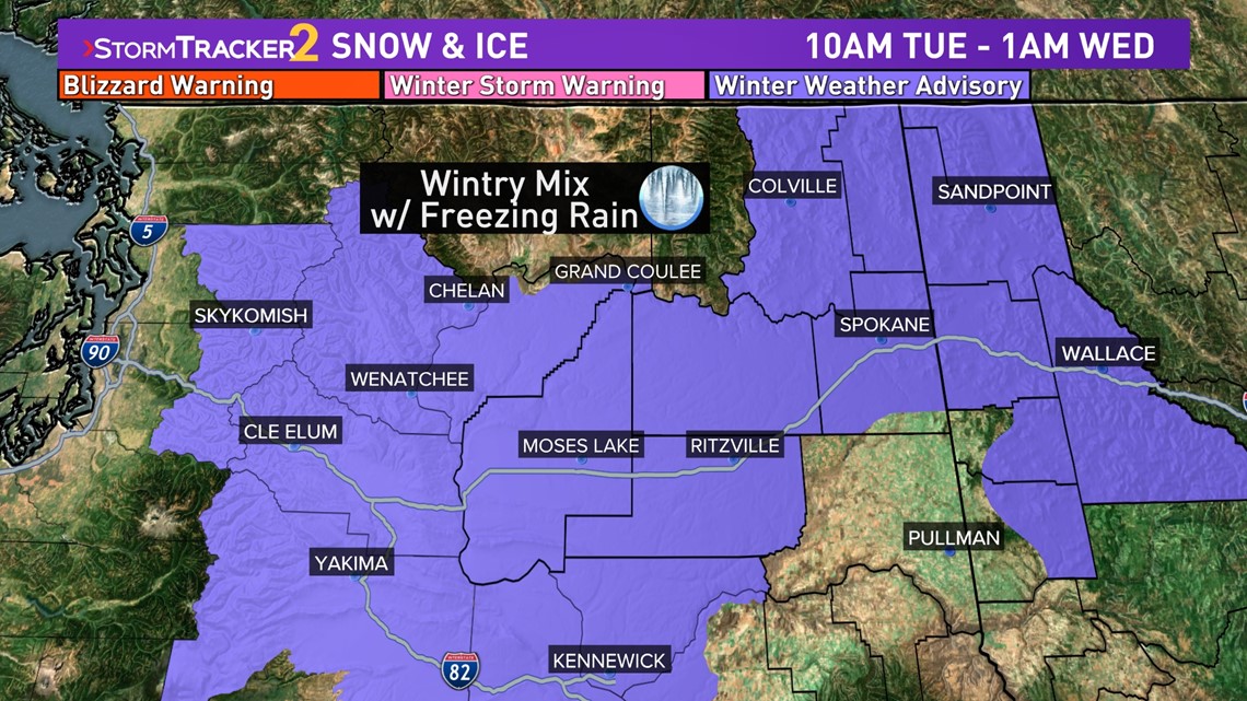
SPOKANE, Wash. — Tuesday's winter storm for the northwest is a complex one in regards to precipitation type, as it will vary depending on the location. The worst of it will be across the northern Columbia Basin, where freezing rain will cause by far the worst road conditions.
A Winter Weather Advisory is in effect for Adams, Lincoln, Grant, Chelan, and Douglas counties from 10 a.m. to 7 p.m. Tuesday. This includes the cities of Ritzville, Moses Lake, Grand Coulee, Wenatchee, Chelan and Leavenworth. The primary concern is for freezing rain and hazardous road conditions during this storm.
Additionally, a Winter Weather Advisory is in effect for the Spokane and Coeur d'Alene areas from 3 p.m. Tuesday to 1 a.m. Wednesday. This includes the cities of Post Falls, Cheney, Downtown Spokane, Coeur d`Alene, Rockford, Davenport, Airway Heights, Worley, Fairfield, Hayden, and Spokane Valley. Ice and snow are likely in these areas Tuesday afternoon through Wednesday morning.
These locations are most susceptible to freezing rain due to a morning temperature inversion keeping surface temperatures below freezing while a warmer layer of the atmosphere will cause for rain to be falling at the time of precipitation before freezing on impact with the ground and idle surfaces.

FREEZING RAIN
Up to one-tenth of an inch of freezing rain is forecast in the Advisory area with a light glaze of ice to mix in with precipitation further east, like in the Spokane area. This should not be enough to cause damage or power outages, but icy roads are likely, especially any roads that are not treated ahead of time.
This may include sections of I-90 and US Highway-2.
TIMING AND PRECIPITATION-TYPE
Spokane and Coeur d'Alene: A cold rain or a rain/snow/slush mix will start around 11 a.m. and continue through 7 p.m. No snow accumulations, aside from the potential for some very wet slush.
Moses Lake and Ritzville: Freezing rain begins around 9 a.m. and could continue through the day. If temps get above 32 degrees during the afternoon, that would halt any ice accumulations and deteriorating road conditions. Precip ends around 5 p.m.
Pullman and Lewiston: An all-rain event from about 11 a.m. to 7 p.m.
Omak: Mostly snow from 7 a.m. to 5 p.m. A rain/snow mix is possible during the afternoon hours. Snow accumulations would be less than 1".
Colville and Sandpoint: Snow from 10 a.m. to 8 p.m. Accumulations around 1-2 inches.
DOWNLOAD THE KREM SMARTPHONE APP
DOWNLOAD FOR IPHONE HERE | DOWNLOAD FOR ANDROID HERE
HOW TO ADD THE KREM+ APP TO YOUR STREAMING DEVICE
ROKU: add the channel from the ROKU store or by searching for KREM in the Channel Store.
Fire TV: search for "KREM" to find the free app to add to your account. Another option for Fire TV is to have the app delivered directly to your Fire TV through Amazon.
To report a typo or grammatical error, please email webspokane@krem.com.