SPOKANE, Wash. — A multi-faceted and powerful storm system hit the Pacific Northwest early Friday. Snow, rain, then wind will all hit the region as the storm moves through. The worst of it will be the wind.
Friday morning began with reports of wet, heavy snow falling across the region. Deer Park woke up to almost 6 inches of fresh snow, Spokane saw anywhere between an inch and 3 inches around town. Snow changed to rain during the day, but as rain winds down, wind picks up.
HIGH WINDS
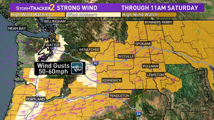
A High Wind Warning has been issued for a majority of the Inland Northwest from 5pm Friday to 11am Saturday morning. Wind gusts up to 60 mph are possible which would cause power outages and tree damage.
The strong winds will have the largest impact on the region and are the priority of the forecast. Southwesterly winds will start to increase Friday evening to 30mph and continue to accelerate up to 50-60mph by Friday night, during the peak of the storm.
The strongest wind gusts will likely occur between midnight and 2am. Should wind gusts near 60mph, that is strong enough to uproot trees or break branches. That could potentially cause widespread power outages across much of the Inland Northwest.
Wind gusts on Saturday will begin around 50mph but decrease back to 30-40mph through the morning, eventually easing through the afternoon.
SNOW
Wet and slushy snow will likely fell Thursday night and Friday morning. Temperatures will hovered around 32-35°, making it a wet and slushy snow. A bulk of the snow melted by Friday afternoon as temperatures climbed and rain fell. Still - this was the first official snowfall of the season!
Below is a map of snow totals and a link to a complete list of snow reports across the region.
What's impressive is just how much precipitation fell on the region. After the snow it was a heavy rain due to an atmospheric river pumping Pacific moisture into the region.
RAIN
If it stayed snow, it would be a significant snow event. But temperatures were too warm and it all changed to rain by Friday afternoon. North Idaho and parts of northern Washington picked up the most rain, upwards of 1-2" of rain and snow-water equivalent in some areas! Spokane picked up more than an inch of rain and snow-water equivalent by 5pm.
Even more impressive, the Seattle area and western Washington got 1-3" of rain with even higher precipitation amounts along the Cascades. With some of that falling as heavy snow before changing over to rain, depending on the snow level elevation. A few locations picked up more than a foot of snow before the rain arrived.
AFTERWARDS
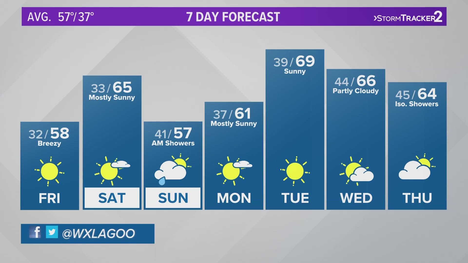
Not covered as powerful, but a separate storm system will hit the PNW Sunday and Monday of next week. This is a strong cold front from the Arctic and Alaska. Far colder temperatures will mean that a chance for snow is likely Sunday and very likely early Monday. With colder temperatures taking us through the middle of the week, it's likely what falls Monday morning will stick around for more than just a few hours.
Be sure to follow KREM 2 Meteorologists Jeremy LaGoo, Thomas Patrick, and Michelle Boss on Twitter for continuous coverage and forecast updates of this upcoming storm.
DOWNLOAD THE KREM SMARTPHONE APP
DOWNLOAD FOR IPHONE HERE | DOWNLOAD FOR ANDROID HERE
HOW TO ADD THE KREM+ APP TO YOUR STREAMING DEVICE
ROKU: add the channel from the ROKU store or by searching for KREM in the Channel Store.
Fire TV: search for "KREM" to find the free app to add to your account. Another option for Fire TV is to have the app delivered directly to your Fire TV through Amazon.
To report a typo or grammatical error, please email webspokane@krem.com.